Monday, 29 August 2011

Day 137 Monday 29th August

We left Mt Gambier at 7.15 this morning. We were pretty much packed up last night so we could leave early this morning. We had to get 4 new tyres on the van this morning, so actually we didn’t leave until 9.00.
We crossed the border into Victoria and set our watches forward ½ an hour. It got colder the closer to the Grampians we got. We arrived at Hall’s Gap and set up in the caravan park. The local oval was full of kangaroos. There had been a big flood in January and the road from Dunkeld to Hall’s Gap had only just opened last weekend. There was a lot of evidence of flooding and landslides.  As we drove into the Grampians we saw 2 mountains; Mt Abrupt and Mt Sturgeon.
Distance travelled today
Total Distance travelled


Sunday, 28 August 2011

Day 136 Sunday 28th August

Last night we went out for dinner to the Mt Gambier hotel. We had a lovely meal and I won $45 on the pokies.
After tea we went to Umpherston Sinkhole. A garden was built by Mr Umpherston in a sinkhole which is an area of land that sunk. It was a lovely area and the possums come out to be fed.
This morning the weather was really windy and cold. We took a drive out to Port MacDonnell where there is a fairy penguin colony; however, we didn’t see any because of the weather. The surf was very rough.


Saturday, 27 August 2011

Day 135 Saturday 27th August

As we were driving the other day I took a photo of this sign. Doug loves it. It is part of a campaign  to highlight the problems driving on the roads in South Australia and we have seen it everywhere.

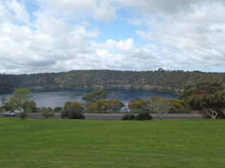
Today  the weather was overcast and cool. We went for a drive around the Blue Lake, Valley Lake, Leg of Mutton Lake and Browne’s Lake. The lakes were formed from dormant volcanoes and get water from underground aquifers. The Blue Lake is used as the town’s water supply and is 70 metres deep.
Then we went into town to see the Cave Gardens. The town is built on limestone and there are a number of caves and sinkholes around.  The Cave gardens are in town and look beautiful but the cave makes you wonder how far underneath it goes.
Then we went to the Lady Nelson Centre which has displays on the early history of My Gambia. There were some interesting displays on the aboriginals, the limestone, the volcanoes and the early settlers of the area.


Friday, 26 August 2011

Day 134 Friday 26th August

We left at 8.30 this morning. It was quite cool and overcast. We called in to Bool Lagoon, a big wet area. There weren’t that many birds around to be seen because there was too much water, not just here but all around the countryside. Anyway it was good to see.
We called in to Penola where there is a Mary McKillop Centre and some old buildings. There was a lot of forestry along the way and we saw some carvings made using a chain saw. We arrived in Mt Gambier and found it very cold and rainy. Hope it warms up tomorrow.
Distance travelled today  229 kms
Total distance travelled  20557 kms


Thursday, 25 August 2011

Days 132 - 133 Wednesday 24th August & Thursday August 25

Day 132  Wednesday 24th August
We left 42 Mile Crossing at 9.00 in the morning and headed off to Kingston S.E. where we saw the Big Lobster.  We didn’t stay here but continued on to Robe.
Robe looked a lovely place and I would have liked to stay here. It had a big marina and some lovely beaches. We went out and saw the Obelisk which was a navigational aide. When you see the cliffs near here you can see why it was needed. Of course, you know that Robe is not famous for robes. Ha Ha.
We then went inland to Naracoorte. We passed some beautiful  fields with heaps of sheep and some cattle. There were also wheat and canola fields. There were many water holes, lakes and lagoons along the way and we later found out that there is a lot of underground water which comes to the surface. This area is the food bowl of South Australia.
Distance travelled today  229 kms
Total distance travelled 20557 kms


ROBE is not famous for ROBES!!


Day  133  Thursday 25th August
Sunshine  yesterday, clouds and wind today. We went out to the Naracoorte Fossil Caves which are a World Heritage site. The first cave we went to was the Victoria Cave. These caves are all in limestone areas and show how the sea receded from this land. This cave had some great limestone formations but the most interesting were the bones and remnants of pre-historic animals. These dinosaurs would fall into a hole and die in there and then their bones were left to be covered over with sediment. It would be interesting to know how far down these layers went.
After that we went into the Wonambi Fossil Centre. Here they have created a section with some of the dinosaurs that were around 100’s of thousands of years ago. Some of these animals were very strange indeed.
After that we went to Wet Cave which was a self-guided cave. It was interesting too. Then we went on a tour of Alexandra cave which went under the carpark and under the café. It had the most beautiful stalactites and stalagmites.


Tuesday, 23 August 2011

Days 130 - 131 Monday 22nd August & Tuesday 23rd August

Day 130  Monday 22nd August
Today we took a drive through the northern part of the Coorong. First we went to Long Point. We saw many birds along the way including pelicans, terns, oystercatchers, ibis, egrets, swans and ducks. The Coorong is a salt lake about 100km long with a relatively thin area of sand dunes before the ocean.
After Long Point we went on a 4 wheel drive track to Mark Point. Here there was an old windmill and trough where the early settlers watered their sheep and cattle. The Coorong is saltwater but there were fresh water springs around.
We continued along the track and wanted to go to Pelican Point. This is where the book and movie Storm Boy was made. Unfortunately the road was blocked and we couldn’t get there. There were also barrages at Pelican Point to stop the salt water from going into Lake Alexandrina.
We then drove on to a town called Narrung. Near this town was an aboriginal community called Raukkan. This was very interesting as it was here that we found the church which is on the $50 note. David Unaipon is also on the $50 note and he was born here in 1872. He became a minister in this church and he was also an inventor which is why he is on the note. We went to the cemetery and saw his grave as well. Unfortunately there was no information about him here but the caravan park manager told us to look for it.
We then went on to Narrung and crossed the Narrows ( a small gap between Lake Alexandrina and Lake Albert) on the ferry. On the other side was a lighthouse which is the only inland lighthouse.
We crossed back on the ferry and returned to our van.
That night we went to the pub for tea and had Coorong Mullet. Yes mother, mullet. It was very tasty.


Day  131  Tuesday 23rd August
We left Meningie at 9.00 this morning and travelled along the Coorong until we got to 42 Mile Crossing. We decided to stay here for the night in the National Park. We drove across to the ocean side and saw surf and sand dunes and millions of shells but no people or buildings. Good fishing here apparently. It was quite beautiful.
Distance travelled today 90 km
Total distance travelled